Tree diagrams are models, not tribal pedigrees
Every branch assumes cognate sets and dating — swap assumptions, tree shifts.
A map of deep linguistic kinship — Indo-European, Sino-Tibetan, Niger–Congo and beyond — without racializing grammar.
Side-by-side cultures and maps — never race ranks.
Read the map layers
Last reviewed Sources & creditsMedia creditsMethodology
Five research punchlines — scan before you dive.
Language families is a reference layer for the Peoples atlas: patterns you can check, not a podium for continents.
Each layer explains what the measure is, where it misleads, and how it connects to culture pages without racial ranking.
Demography and linguistics change; treat figures as era-bound.
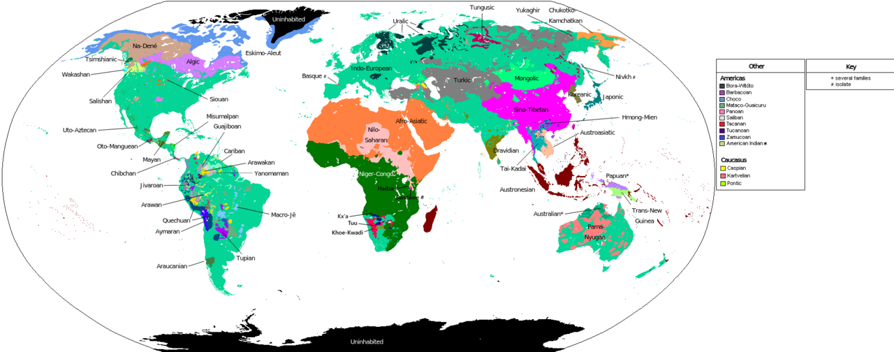
What Language families measures and why it matters.
This layer exists to answer “where?” and “how connected?” without sliding into “who is better?”
Read it beside culture pages: tongues, cities and migrations are how peoples actually meet.
Languages with a reconstructed common ancestor, demonstrated by systematic sound correspondences — not by the looks of speakers.
A few families cover huge speaker counts; thousands of others are local and vulnerable.
Sprachbunds share features across family lines (Balkans, Mainland Southeast Asia).
English, Spanish, French and others overlay older maps without erasing them.
Related languages can be spoken by people with very different ancestries after shifts and conquests.
Signals a careful reader looks for — and the traps that turn maps into myths.
Every branch assumes cognate sets and dating — swap assumptions, tree shifts.
Niger–Congo and Austronesian sprawl reflects time and farming spreads, not IQ.
Basque, Ainu and others remind you families have orphans — don't force boxes.
Missionary grammars named "tribes" that atlases still copy — ask who named the group.
Scholarly themes rewritten for curious readers — not paywalled jargon, and never a race ranking.
Regular sound correspondences let linguists group languages into families — a method, not a racial census.
Takeaway Cognates beat coincidence.
Bellwood-type models link some spreads to agriculture; critics demand case-by-case proof.
Takeaway Big stories need local tests.
Wave models capture dialect continua that pure trees distort — important for Europe, India and beyond.
Takeaway Not every relationship is a branch.
Missionary grammars and colonial surveys invented ethnonyms that stuck in atlases.
Takeaway Who named the family?
Bayesian trees look authoritative; garbage cognate sets in, garbage history out.
Takeaway Pretty graphs need clean data.
Books, reviews and museum trails — starting points, not a syllabus.
Survey of major families for beginners — method, not racial census.
Sound correspondences and cognates — how linguists build trees.
World atlas of endangered languages displays — politics of naming.
Field linguists racing to document dying tongues — urgency without fatalism.
Online catalog with references — check counts and disputes.
No. Atlas pages refuse superior/inferior framing.
When masters revise; UN and linguistic datasets move — check dates in prose.
Yes, with attribution to Tool-Lifes and underlying public datasets named in text.
Reusable licences and stable Wikipedia titles feed our media pipeline.
No. They show languages, density, migration or methods — never race league tables.
Cultural pages note conflict when relevant; atlas layers prefer demographic basins over propaganda maps.
The metric is not; using it to rank human worth is.
Pair this page with Race is not biology in the diversity pillar.